Start Point: The layby at the start of Doctors gate.
End Point: The layby at the start of Doctors gate.
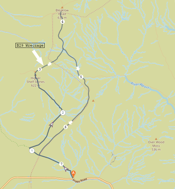
An almost out and back route heading up Doctors gate, past the intersection with the Pennine way, turning off and following the path to Higher shelf stones, viewing the crash site, then cutting across the moor to the Pennine way and up to Bleaklow Head befire turning around and coming back down the Pennine way.
Distance: 7.2km
Difficulty: Easy
Rating 4/5
After our unsuccessful attempt to reach the crash site two weeks prior, we decided that we were ready for our rematch. Thankfully on our second attempt the weather was much, much nicer and we did not have to contend with extremely poor visibility and sideways rain. Navigational errors did still occur, because is it really a hike if you don’t make a wrong turn somewhere? Despite going the wrong way for a bit on the way back we returned to the car safely at the end of the day, discovering that it’s much easier to find your way around Bleaklow when you’re not sat inside a cloud. Once again, I have shared the route we were supposed to walk and have left our little detour off the route map.
This time around we decided to park closer, using the layby at the foot of the Doctors Gate path as our launch point. This particular layby can probably get five cars in it comfortably and there is another larger layby a bit further down the road that most people seem to use for the walk to the crash site, but it get’s busier much faster than the one we decided to use. A little extra walking for a quieter parking spot felt like a reasonable trade off.
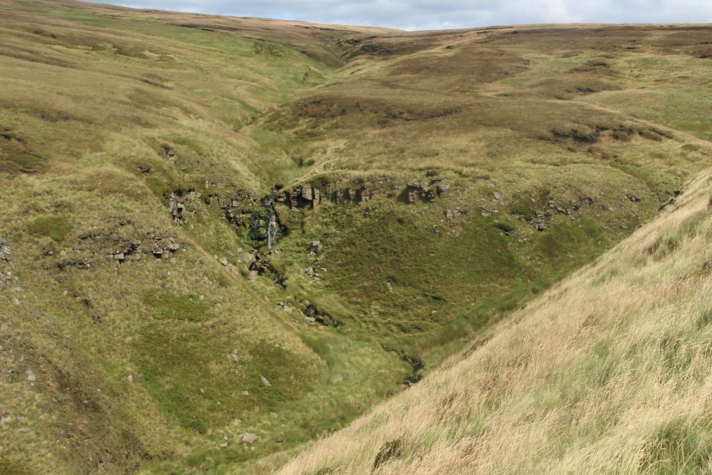
We made our way up Doctors Gate and when we reached the intersection with the Pennine way we walked a little further until we came to another path turning off north east. This path led us along the east side of Crooked Clough until we past a very pretty waterfall, after which the path curved north west up towards Higher Shelf stones. At the trig point on Higher Shelf stones we then turned north east and after about another minutes walk we arrived at the crash site.
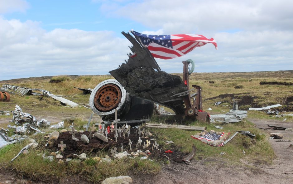
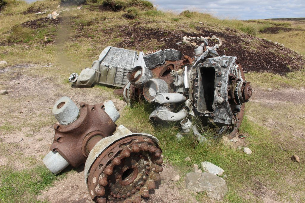
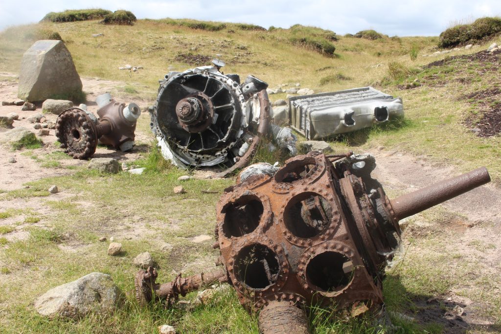
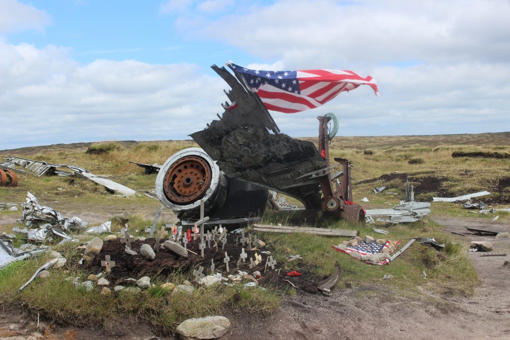
I was expecting the visit to the B29 wreckage to be quite somber, but it definitely hit me a bit harder than I expected it would. Firstly, it struck me how much wreckage there was. This was not a small plane. The second thing was the gradual realisation that this entire plane wreck had been here since 1948. It has remained untouched. Aside from the information plaque that has been placed there and the memorial that has been created out of the wheel housing, this wreckage has been here on Bleaklow since the day of the crash and none of it has been moved.
There were 13 crew on the plane, members of the US air force. None of them survived the crash. Exactly what happened on that day remains a mystery. They were running an errand flight and no distress signal of any kind was sent. The weather was cloudy and another 500m past that point the land does drop away, so the assumption is that they were trying to keep visual on the ground due to the poor weather and a navigational misjudgement meant that they descended too soon, resulting in the plane crashing before they could react to the situation.
After exploring the crash site we found a sheltered spot to sit and have our lunch while we contemplated the wreckage. The quickest way to get from the crash site to Bleaklow Head was to strike across the moor in the direction of the summit. It was about 500m from the crash site to the nearest point of the Pennine way and although we didn’t take a compass bearing, this might be something you want to do if you’re less confident. There is an unmarked footpath that runs from the Pennine way to the crash site which you can follow if you aren’t comfortable moving across the moor, it will just add a little distance to the overall trip.
We made some naviagtional misjudegments once on the Pennine way. The mapping app I was using had the Pennine way marked incorrectly, so we thought we were following a different path up to Bleaklow Head, and then we thought we’d come back down what the map said was the Pennine way. It turns out the path we followed up to Bleaklow Head was actually the Pennine way and the Pennine way on the app was a less well marked path that we ended up making a wrong turn on on the way back. Always check the physical map!
Neither of us has visited Bleaklow Head before so it was great to get up there and see the view across most of the Peak District and out towards Manchester. With good visibility the Kinder Plateau dominates the skyline to the south, the buildings of Manchester city centre can be seen clearly to the west, Black Hill sits to the north and Derwent Edge is visible to the east. It was amazing how much we could see from up there and I felt lucky that the visibility was so good on that particular day.
Heading back we accidentlly went down the wrong path and ended up walking west for a while before we realised we were walking too much towards Manchester and got the map out to check where we’d gone wrong. A little bit of backtracking later and we were back on the Pennine way heading south. Following the path south was easy enough and it took us back to the intersection with Doctors Gate where we turned south east back towards the car.
On a clear day with good visibility this route is beautiful and very easy, particularly if you just want to go to the crash site and then back to the car. Adding the walk up to Bleaklow Head is simple enough, just make sure you pay attention to which paths you’re taking and don’t blindly follow one without checking, like we did! I’d definitely reccomended walking up to Bleaklow Head if the visibility is good as the views are fantastic. This route becomes much harder when the visibility is poor as some part of the path up to Higher Shelf stones are not that clear and finding your way across to the Pennine way also becomes trickier, so check the weather forecast beforehand!
Thank you for reading! Be sure to check back weekly for walking routes, gear reviews and adventures.